The Computational Archaeology Laboratory at San Diego State University is a state of the art facility for computational approaches in archaeology and geoarchaeology. Specialties include GIS, agent-based modeling, imagery analysis, advanced statistical modeling, 3D analysis, as well sedimentology, granulometry, geomorphology, landscape analysis, and geochronology. A main focus of research is on the origins and long-term dynamics of coupled human and natural systems, including anthropogenic landscapes, in the Mediterranean and beyond.
Lab Information
Location: Hardy Tower 62/66.
The lab is located on the ground floor of the Hardy Tower building. Students should enter through HT 62 door in the stairwell (look for “Computational Archaeology Laboratory” signs).
*Supervised Lab Hours:Fall 2025 - Thursdays 9a-3p*
Research
| Research topics | Methods | |
|---|---|---|
| • Coupled human-natural systems research |
• GIS and spatial analysis | |
| • Anthropogenic landscapes, sediments, and soils |
• Agent-based modeling | |
| • Agro-pastoral landuse and subsistence | • 3D and multispectral imaging |
|
| • Long-term human socio-ecology | • Sediment analysis and geomorphology |
|
| • Human eco-dynamics | • Scientific computing and machine learning |
|
| • Landscape evolution | • Archaeological survey | |
| • Human-climate interaction | • Paleoenvironmental reconstruction |
| Collaborations | Funding and support |
|---|---|
| • The Mediterranean Landscape Dynamics Project |
• The National Science Foundation |
| • The Bova Marina Archaeological Project |
• The National Endowment for the Humanities |
| • The Wadi Ziqlab/Wadi Quseiba Project |
• The Social Science Research Council, Canada |
| • The Center for Climate and Sustainability Studies |
• The SDSU University Grants Program |
Students
The Computational Archaeology Lab provides computing and other resources for undergraduate and graduate student research in the fields of Computational Archaeology and Geoarchaeology. There are ongoing opportunities for undergraduate student research volunteers and internships (for credit) and occasionally a limited number of paid hourly positions as well. Please email me if you are interested.
Prospective Master’s Students
I am currently seeking prospective MA students interested in the fields of Computational or Digital Archaeology, Geoarchaeology, and Landscape Archaeology. I am particularly interested in students with some background in GIS or other computational approaches and/or the geosciences. I have ongoing research opportunities for students interested in working in the Mediterranean region, San Diego County, or in Central Eurasia. I have active fieldwork in Southern Italy and in San Diego County, and other opportunities may also include data from past fieldwork in Spain, Jordan, or Kazakhstan. Interested prospective students should email me to discuss potential thesis topics further. You are also advised to visit the main Anthropology MA program page for more information about our graduate studies program.

Courses
The following courses are partially taught in the lab, have open lab hours in the lab, or use lab resources.
- ANTH 562 Computational Archaeology
(Activities: GIS, Imagery Analysis, LiDAR, 3D modeling) - ANTH 563 Anthropogenic Landscapes
(Activities: Geoarchaeology, Erosion Modeling, Sediment Granulometry, Agent Based Modeling)
Lab Resources
Hardware
The lab has the following hardware resources available for teaching and research in the areas of computational archaeology and geoarchaeology:
- Computation:
- 5 high-power Ubuntu Linux computer workstations. These workstations are available to my graduate students and students in my courses to complete assignments and conduct research.
- A Puget Systems “Peak” HPC workstation. This workstation contains 44 multithreaded cores for parallel and high-performance computing.
- 1 Windows 95 computer for legacy software
- Wacom tablets for data entry and digitization
- High-capacity external hardrives for long-term data storage
- 3D Scanning and Photogrammetry:
- Livox Avia LiDAR scanner with mobile battery and laptop connection kit
- Insta360 360 degree cameras
- Creality structured light 3D scanner
- Turntables and light tents for 3D scanning and object photography
- MapIR Survey2 Red-NIR NDVI camera
- MapIR luminosity calibration target
- Xrite Color checker chart and grey cards
- Pantone Huey screen profiling calibration tool
- Tripods and lighting
- High resolution Canon flatbed and film scanner
- Our field workflow can be found here.
- Sedimentology and Granulometry:
- Beckman Coulter Multisizer 3 Particle Size Analyzer (~0.1 to 1000 microns)
- ISO standard nesting geologic sieves
- Mechanical sieve shaker
- Precision balance
- pH, Salinity, and TDS meter
- Bouyoucos hydrometers, hydrometer flasks, and reagents
- Mixers, dehydrators, glassware, etc.
- We follow the KBS LTER protocols for sediment particle analysis via hydrometer method, measuring soil moisture, for measuring soil pH and conductivity, and for measuring soil bulk density.
- Digital Field Data Collection:
- Android phones for field data collection using Open Data Kit.
- Bad-Elf GNSS surveyor high precision bluetooth GPS units.
- 2 small (but old) Ubuntu Linux laptops for dirty field locations
- Our mobile data collection workflow can be found here.
- Artifact Analysis:
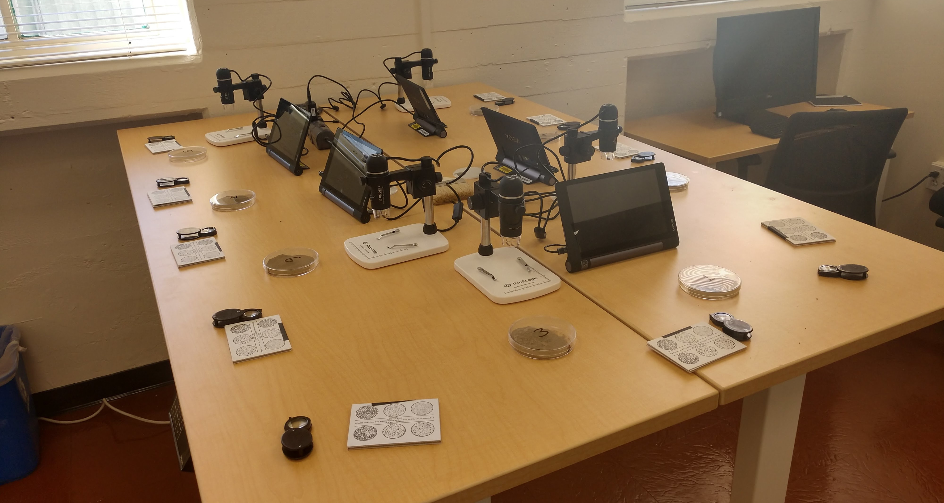
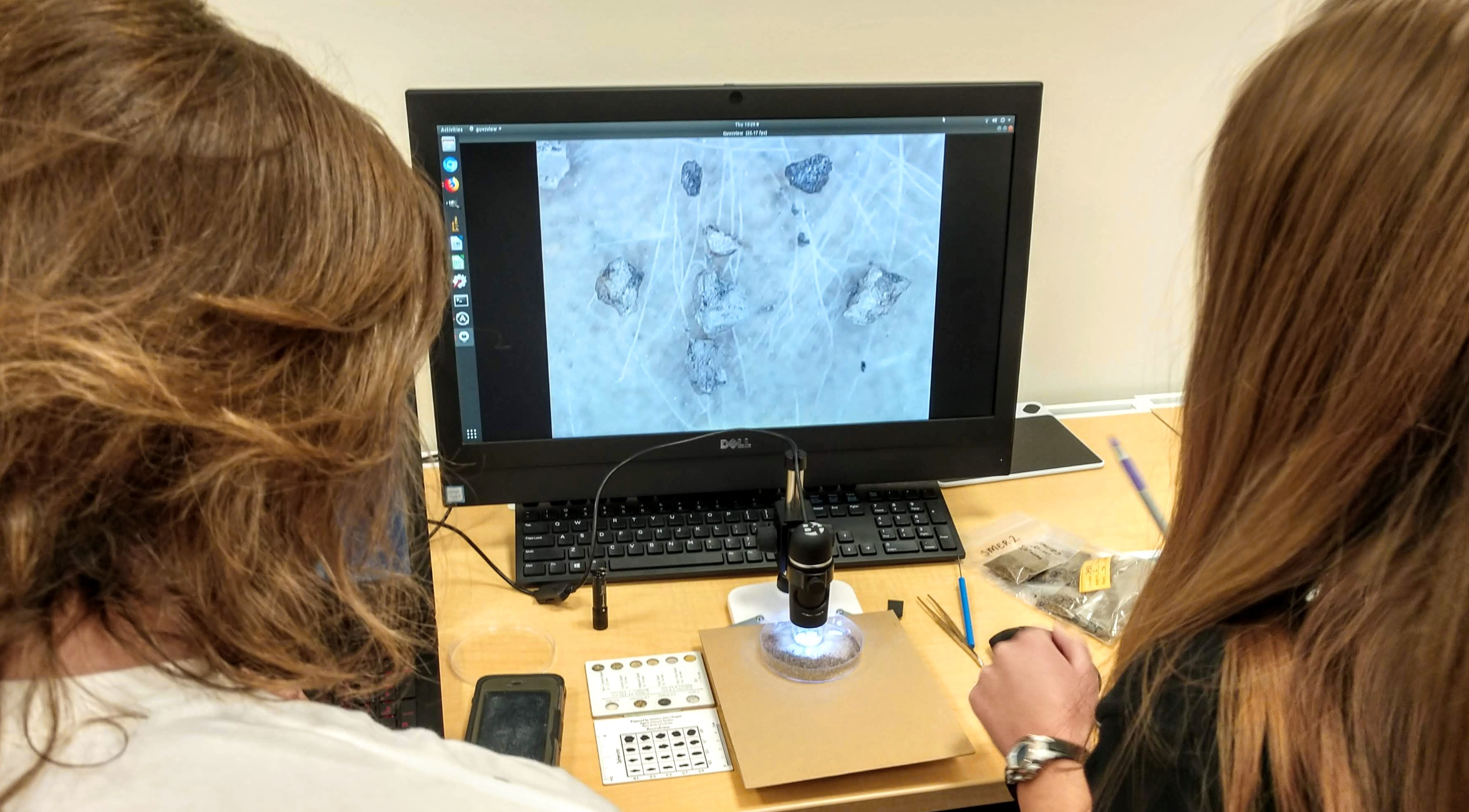
- Low-power USB microscopes for conducting microrefuse analysis or other such tasks.
- Calipers, profilers, and other measurement tools
- Assorted glassware and other laboratory tools
- Experimental archaeology collectiong
- Flintknapping materials and supplies
- Archaeological and Geoarchaeological Fieldwork:
- Sediment auger (regular, sand, and wide buckets)
- OSL sampling tools
- Tools and guides for in-situ sediment descriptions
- Tapes, levels, tools, etc., for survey and excavation
Software
The lab specializes in Free and Open Source Software (FOSS) approaches to computational archaeology, with teaching and research strengths in the following software areas:
- GIS:
- GRASS GIS
- QGIS
- Q-Field
- Agent Based Modeling:
- NetLogo
- Python
- Image Analysis
- Image-J
- GIMP
- Darktable
- Open CV
- Photogrammetery and 3D Scanning
- Open Drone Map (and WebODM)
- Open CV
- MVE
- Meshroom
- Livox Viewer
- Meshlab
- CloudCompare
- Scripting, Programming, and Data Science
- Python (Pandas, NumPy, SciPy, Matplotlib, Seaborn, etc.)
- R
- BASH/Shell Script